


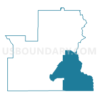
Mapleton 11 Voting District, Franklin County, Idaho
About
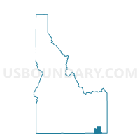
Outline

Summary
| Unique Area Identifier | 564037 |
| Name | Mapleton 11 Voting District |
| County | Franklin County |
| State | Idaho |
| Area (square miles) | 128.40 |
| Land Area (square miles) | 128.37 |
| Water Area (square miles) | 0.04 |
| % of Land Area | 99.97 |
| % of Water Area | 0.03 |
| Latitude of the Internal Point | 42.05898390 |
| Longtitude of the Internal Point | -111.66195100 |
Maps

Graphs
Select a template below for downloading or customizing gragh for Mapleton 11 Voting District, Franklin County, Idaho


Neighbors
Neighoring Voting District (by Name) Neighboring Voting District on the Map
- Bloomington Voting District, Bear Lake County, ID
- Fish Haven Voting District, Bear Lake County, ID
- Franklin 10 Voting District, Franklin County, ID
- Garden City Voting District, Rich County, UT
- Mink Creek 12 Voting District, Franklin County, ID
- Paris Voting District, Bear Lake County, ID
- Preston 5 Voting District, Franklin County, ID
- St Charles Voting District, Bear Lake County, ID
- Treas-Riverdale 14 Voting District, Franklin County, ID
- Unpopulated Voting District, Cache County, UT
- Whitney 16 Voting District, Franklin County, ID
Top 10 Neighboring County Subdivision (by Population) Neighboring County Subdivision on the Map
- Preston CCD, Franklin County, ID (9,398)
- Paris CCD, Bear Lake County, ID (1,729)
- Garden City-Laketown CCD, Rich County, UT (1,226)
- Mink Creek CCD, Franklin County, ID (956)
- East Cache CCD, Cache County, UT (105)
Top 10 Neighboring Unified School District (by Population) Neighboring Unified School District on the Map
- Cache School District, UT (64,634)
- Preston Joint School District 201, ID (10,253)
- Bear Lake County School District 33, ID (5,835)
- Rich School District, UT (2,264)
Top 10 Neighboring State Legislative District Lower Chamber (by Population) Neighboring State Legislative District Lower Chamber on the Map
Top 10 Neighboring State Legislative District Upper Chamber (by Population) Neighboring State Legislative District Upper Chamber on the Map
Top 10 Neighboring 111th Congressional District (by Population) Neighboring 111th Congressional District on the Map
Top 10 Neighboring Census Tract (by Population) Neighboring Census Tract on the Map
- Census Tract 9702, Franklin County, ID (6,718)
- Census Tract 9701, Franklin County, ID (6,068)
- Census Tract 9502, Bear Lake County, ID (2,547)
- Census Tract 9501, Rich County, UT (2,264)
- Census Tract 9801, Cache County, UT (105)
Top 10 Neighboring 5-Digit ZIP Code Tabulation Area (by Population) Neighboring 5-Digit ZIP Code Tabulation Area on the Map
- 84321, UT (44,074)
- 83263, ID (9,258)
- 83237, ID (1,146)
- 84028, UT (824)
- 83272, ID (313)
- 83287, ID (299)